Captain’s Blog
Friday
August 28, 2009
Our plan for the day was to get up and out early for the 9:00 am Ranger led cave walk into Indian Tunnel. Ron didn’t sleep well because he has been having right ear pain and he normally sleeps on his right side. Once he finally fell asleep he slept until 9:00 am so we opted for the 4:00 PM walk.
We drove along the loop and stopped at Devil’s Orchard  where island-like lava fragments stand in a sea of cinders. Devil’s Orchard formed over two thousand years ago when nearby volcanoes erupted so violently that they tore themselves apart. Rivers of lava floated huge chunks of crater wall down to what is now called Devil’s Orchard. As time passed, rocks crumbled and the seeds of rabbit brush and pine took root in the sparse soil. A hundred years ago a visiting minister declared the jumble of rocks, shrubs and trees to be a garden for the devil himself.
The formations are unusual and the trees grossly deformed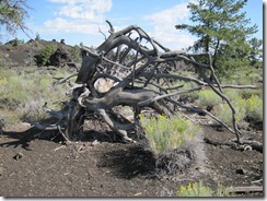
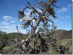
 but beautiful in an eerie way.
The area makes one pause to think about the ferocity of the eruption that sent the huge volcanic boulders flying across the landscape landing without form or reason.
Later we took the Broken Top Loop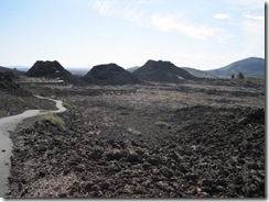 Trail a hike up, around and through the freshest lava on the Snake River Plain. Along the 1.8 - mile trail we were able to observe most of the volcanic features that make up the unearthly landscape.
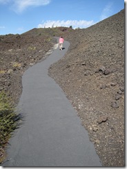
When looking for the volcano we had to remember that we were actually looking at it although not a conventional volcano like Mount Saint Helen’s. The depression we were walking through was one of a series of tears in the earth that are the source of the Craters of the Moon lava field. Broken Top was formed as frothy, molten rock was sprayed high into the air from linear eruptive fissures. As the cinders fell back to earth and piled up, they formed a cinder cone.
Looking to the northern horizon we could see where the lava stopped and the foothills of the Pioneer Mountain began. That is the northern boundary of the huge mass of lava known as the Eastern Snake River Plain, which covers more then 7,500 square miles. WOW! That’s a lot of lava.
Along the trail we walked on crunchy cinders. The cinders contain many gas bubbles and vesicles making them very light weight. Thin layers of glass coat the cinders creating prisms that refract and reflect light into millions of micro-rainbows. They are quite beautiful and cannot be taken for souvenirs.
We could see the large peak of Big Southern Butte 25 miles to the east of us. It lies outside the boundaries of the park and looks like a stratovolcano but is not. It is a massive dome of rhyolite rock. Rhyolite is composed of the same minerals as granite but in lava form. It is estimated that about 300,000 years ago rhyolite lava slowly rose up through the layers of dark basalt and broke through the surface to form the Big Southern Butte Peak.
 We then were warned to watch out for bombs!!! Not real bombs but bombs that were created by globs of molten rock that were called bombs when they were thrown out through the fissure during the formation of Broken Top. The place was covered with round bombs, some weighing over 100 pounds. There were two other types of bombs strewn about. One called a “Breadcrust” bomb that had a outer layer that would crack like the crust on bread. “Spindle” bombs would form as hot lava spirals through the air, freezing into twisted bizarre shapes. We were fortunate to see them all.
We stopped to view the pressure flow ridge formed when crusts of cooling lava encapsulates the hot flowing lava below creating a roof. As the pressure under the roof increased it forced the crust upward causing it to bend and buckle. There were rounded, bulbous projections called lava toes at the base of the ridge. I’m not sure if we captured it well on film.
 Next we stopped at the buffalo caves but since Ron didn’t bring a flashlight we weren’t able to get into them. They didn’t look very stable anyway and the area had experienced some rock slides. Buffalo Cave is part of the lava tube system of the Broken Top flow.
Big Cinder Butte could be seen from the trail and at over 700 feet high is the largest cinder cone in the park. It is believed that a fountain of fire at least 1,500 feet high produced Big Cinder Butte.
The hike across the pahoehoe 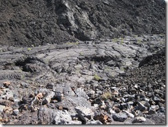
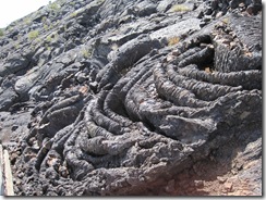 (means ropy in the Hawaiian language) lava flows was incredible and awe inspiring. We have walked across lava flows in Hawaii but these were unique in every way.
After leaving Broken Top we headed back to the MH for lunch. Then on to another hike with Ranger Lennie to Indian Tunnel the remnants of a huge lava tube the result of the Blue Dragon Lava Flow about 2,100 years ago. Sheets of lava ran down the slope from a fissure and in some places the lava flowed in channels. The surface of the channels hardened, forming tubes that transported molten rock. Eventually the flow covered an area of 100 square miles and some of the lava tubes more then 30 feet high. In some places the lava is an iridescent blue (really beautiful), the result of titanian magnetite crystals suspended in the glassy rock surface. Hence the name “Blue Dragon Flow.”
When we reached the Indian Tunnel we had to take a very steep staircase  down and then hop over rocks to get to a level surface. The lava tube (cave) was enormous. The size of the tube is 30’ high, 50 ‘ wide and 800’ long. We had been in lava tubes in Hawaii and also under Mount Saint Helen’s but this tube dwarfed both.
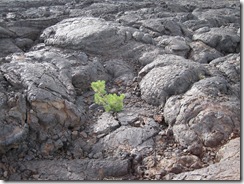
After Ranger Lennie gave his talk we were left to our own devices. Either leave with him or continue on to the other end of the cave and climb out. Of course Ron wanted to traverse the cave so not wanting to be considered a wimp I joined him. We met a very nice woman and her twelve-year old son (our Grandson Steven’s clone) and they joined us on the journey up and over the rock piles and through the small opening to the outside. It was a lot of fun and Ron was happy that I didn’t wimp out on him. 
Of course one cave is never enough so we all went to explore Beauty Cave a 300 foot cave that you enter through a large opening and scramble down a slope of large rocks to the smooth pahoehoe floor . The cave was very dark and we had to use our flashlights. Unfortunately there had been a collapse so were unable to travel the 300 feet. 
We returned to the MH and with no time for dinner we headed out on the evening stroll with Ranger Tiffany for a panoramic view of the North Crater Cinder Cone. The ¼ mile hike uphill was worth the view. It was spectacular to say the least. It is amazing that such a desolate monochromatic place could be so very beautiful. Tiffany, our geologist, was put to task by some very difficult, rude people asking difficult questions but she met the challenge and impressed the heck out of us.
Back at the MH I threw together a quick dinner and then it was off to the evening Ranger Program. The guest speaker was a meteorologist from the National Weather Service. He was quite good but very technical. We enjoyed the program and were surprised to learn of the many varying components that go into predicting and reporting weather.
Finally, after a very busy day we headed to the MH and to bed. Ron wants to stay one more day and hike the North Crater Flow Trail, the longest trail in the park. More adventures tomorrow.
 I know this will sound weird but Ron and I both love it in this rock-strewn, colorless place. We have enjoyed the hikes, programs and even the silver fox that came through our campsite last evening. Jewel loves it here also and has made herself a very comfy dirt bed. All this for only five dollars a night.


 walked over ancient lava flows and enjoyed the spectacular view from the highest elevations I have ever hiked. Hiking the 1.8 miles at 6000 feet over rocky terrain, down steep inclines and over lava flows was not as difficult as walking from the end of the trail on the paved road back to our starting point. We opted to take the road instead of back over the rough terrain but by the end of the first mile we were thinking we should have retraced our steps. It was easier to walk on rough terrain then on the tarred roadways.


